This lead state team has completed all planned activities and is no longer active. The information below, as created by the active lead state team, remains available for review by users seeking additional information.
UPlan
What is UPlan?
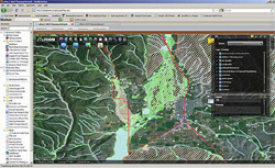
UPlan can display critical environmental attributes such as streams, wetlands, rare plant habitat, and other attributes on top of planned roadway capacity needs for any location in Utah.
UPlan is a powerful yet easy to use web based decision-support mapping and informational tool for completing complex planning and project development tasks. It allows complete or selective data sharing among various work units within the state DOT. It also allows selective data sharing between state DOTs and with the public. View the
technology nomination form or the
UPlan Map Center website online.
John Thomas, UPlan Project Manager
Utah Department of Transportation
801-550-2248
johnthomas@utah.gov | Frank Pisani, UPlan GIS Lead
Utah Department of Transportation
801-633-6258
fpisani@utah.gov |
Bill Shaw, UPlan Knowledge Specialist
Idaho Department of Transportation
208-745-5608
Bill.Shaw@itd.idaho.gov | Tom Palmerlee, UPlan Special Advisor
Associate Director
Technical Activities Division
Transportation Research Board
202-334-2907
TPalmerlee@nas.edu |
Mark Sarmiento, UPlan Special Advisor
Office of Planning
Federal Highway Administration
202-366-4828 | 202-630-4828 (on Mon. and Fri.)
Mark.Sarmiento@dot.gov | |
Friends of the Team: | |
Terry Bills, Technical Associate
UPlan Implementation Team Leader
Transportation Industry Manager
ESRI
909-793-2853 ext.13313
tbills@esri.com | Andrea Moser, Technical Associate
UPlan GIS Lead
Bio-West
435-752-4202
amoser@bio-west.com |
UPlan Library
- Fast-Fact Sheets
(Available for download/desktop print.)
- Hand-Outs
- Presentations
-
UPlan Demo
2012 Esri International User Conference
John Thomas, UDOT Planning Director and
Frank Pisani, UDOT GIS Manager
Introduction by Bern Szukalski
(July 23, 2012)
- Additional Resources
- Technology Nomination Form and Supporting Material