Linear Referencing System
This lead state team has completed all planned activities and is no longer active. See the
closeout report or
closeout overview for a summary of lead state team accomplishments. The information below, as created by the active lead state team, remains available for review by users seeking additional information.
What is a Linear Referencing System?
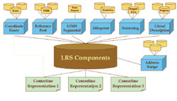
Linear Referencing System Data Model
A location referencing system (LRS) is "a set of office and field procedures that include a highway location reference method." A location referencing method (LRM) is a "way to identify a specific location with respect to a known point" (Baker, W. and W. Blessing. (1974). Highway Linear Reference Methods, Synthesis of Highway Practice 21. National Cooperative Highway Research Program. National Academy Press. Washington, D.C.).
The Iowa LRS was designed using the results of the National Cooperative Highway Research Program (NCHRP) 20-27(2) project. The NCHRP 20-27(2) linear LRS data model was developed in response to a growing awareness of the need to integrate increasing amounts of linearly-referenced data used by the transportation community (Vonderohe, A.P., Chou, C.L., Sun, F., and T.M. Adams. (1997). "A Generic Data Model for Linear Referencing Systems", Research Results Digest 218, National Cooperative Highway Research Program, Transportation Research Board, Washington, D.C., August, 28 pp.).
Benefits
Combining information from different data sources within a department of transportation has been an information processing concern. Spatial data, whether in the form of a mile marker, literal description or other location component, has varied in the many different databases used over the years. Since a vast majority of the data collected is referenced to the Earth in some manner, the use of spatial location and Geographic Information System products is the logical choice to accomplish this integration. The Linear Reference System (LRS) aligns the linear reference points in all databases so information from crash statistics, pavement management and other business data can be accurately mapped and data more easily analyzed. Through this integration, the LRS improves data integration and access, improves accuracy, minimizes redundancy in the databases, minimizes data maintenance activities and includes all public roads.
An improved road network is very important in many areas. Safety professionals make extensive use of the road network to plan and execute engineering, enforcement, education and emergency response treatments for safety problems. Routing and Navigation utilize the road network to solve the problem of shortest path to a selected destination from current vehicle position. Tying the data together from throughout all areas via location improves our ability to manage our road systems. Through the investment in the LRS, the DOT's are able to provide a base for emergency response coordination across jurisdictions.
It is the desire of the Lead States Team to assist other states in creating and/or enhancing their LRS.
Contacts – Lead States Team
LRS Library
- Brochure
- Presentations
- Other Publications
- Additional Resources
