This lead state team has completed all planned activities and is no longer active. The information below, as created by the active lead state team, remains available for review by users seeking additional information.
Environmental Planning GIS Tools for Transportation Planning
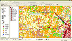
GISST analysis can be used to communicate with a wide variety of stakeholders because of its easy to understand ranking system.
What are Environmental Planning GIS Tools?
Environmental Planning GIS Tools provide a scalable solution that uses mapping technology to analyze environmental assets along with transportation assets and plans to develop optimal paths for both transportation improvements and environmental mitigation and stewardship. The process involves early multi‑agency integration, which expedites project delivery. This process serves a Green Infrastructure approach, which is a strategically planned and managed network of natural resources that provides an ecosystem‑based framework for selecting corridor alignments and identifying mitigation opportunities.
Benefits
Data-driven Decision Support System
- Defensible decisions
- Speed project planning and delivery without sacrificing environment
- "Smart" mitigation without sacrificing environment
- Transparent decision-making
- Improve project quality
- Cost efficiency
- Enhanced credibility
Early Multi-agency Integration
- Speed project planning and delivery without sacrificing environment
- Strengthens working relationships
- Transparent decision-making
- Cost efficiency
- Eliminate redundancy
- Improve information quality
- Align with Federal priorities
- Regulation/compliance
- New compensatory mitigation rule
- SAFETEALU requirements
- NEPA
Systems Approach
- Higher quality of stewardship
- Cost efficiency of stewardship
- Scalable activity
- Framework provides leveraging of project dollars to multiply ecological benefits
- Strengthening communities through sustainable practices
- Environmental
- Economic
- Social
- Agency public image enhancement
- Public approval and cooperation
- Enhanced credibility
- Defensible decision framework
- Supports Federal initiatives
- FHWA "ECO-LOGICAL"
- Fish & Wildlife Services Strategic Habitat Conservation
- US EPA and Army Corps of Engineers watershed approach
- US Forest Service programs
- US Department of Defense "Linking Fences Linking Missions" program
- Other linear infrastructure programs are using GI approach (pipelines, etc.)
Contacts – Lead States Team
Gregory I. Slater, Chair
Director, Office of Planning and Preliminary Engineering
Maryland
SHA
410-545-0412
gslater@sha.state.md.us | Maya Coleman
Information Resource Coordinator, Environmental Affairs Division
Texas
DOT
512-416-2578
maya.coleman@txdot.gov |
Christine Conn, Ph.D.
Office for a Sustainable Future
Maryland
DNR
410-260-8785
cconn@dnr.state.md.us | Troy Sykes
GIS Specialist, Environmental Affairs Division
Texas
DOT
512-416-2571
troy.sykes@txdot.gov |
Donna Buscemi
Team Leader, Environmental Planning Division
Maryland
SHA
410-545-8558
dbuscemi@sha.state.md.us | Andrew Blair
Biologist, Environmental Affairs Division
Texas
DOT
512-416-2534
andrew.blair@txdot.gov |
Heather Lowe
Team Leader, Environmental Planning Division
Maryland
SHA
410-545-8526
hlowe@sha.state.md.us | Sharon Osowski Morgan, Ph.D.
Ecologist
US EPA Region 6
214-665-7506
Osowski.Sharon@epamail.epa.gov |
Sandy Hertz
Deputy Director, Office of Environmental Design
Maryland
SHA
410-545-8609
shertz@sha.state.md.us | Kris Hoellen
Director, Conservation Leadership Network
The Conservation Fund
304-876-7462
khoellen@conservationfund.org |
Charlie Gischlar
Office of Communications
Maryland
SHA
(410) 545-0311
cgischlar@sha.state.md.us | Will Allen (as an alternate)
The Conservation Fund
wallen@conservationfund.org |
EPGT Library
-
Brochure
- Presentations
-
GIS and Optimization Tools for Linking Transportation and Natural Resource Planning: An Approach for Optimizing Mitigation in a Fiscally Constrained Environment
NHIInnovations - Webinar
(December 20, 2012) -
GIS Tools for Linking Transportation and Natural Resource Planning
NHIInnovations - Webinar
(October 18, 2012) -
Linking Transportation and Natural Resource Planning through Environmental GIS Tools
NHIInnovations - Webinar
(June 16, 2011) -
Landscape Scale Planning: Innovative Tools Used by MD SHA and TX DOT
2011 MdQI Conference
Donna Buscemi, Sandy Hertz, and Heather Lowe; Maryland State Highway Administration
Christine Conn, Maryland Department of Natural Resources
Gannett Fleming, Craig Shirk
(February 3, 2011) -
US 301 Waldorf: A Strategic Approach to Environmental Stewardship
Will Allen, The Conservation Fund
(August 2010) -
Environmental Planning GIS Tools for Transportation Planning and Design
ESRI International User Conference
Maya Coleman, Texas Department of Transportation
(July 14, 2010)
- Other Publications
- Additional Resources
